

Weather Service Reveals Dangerous Forecast Ahead of Season’s First ‘Real’ Cold Front
(KMDL-FM) Forecasters with the National Weather Service are suggesting that Mother Nature will finally answer a request that most people in Louisiana have been making since early May. That is a request for cooler temperatures.
Your prayers have been heard; that should be coming later this week in the form of a cold front, but that storm system will be preceded by an unusually dangerous forecast for portions of Central and Southern Louisiana.
What Is the Current Weather Danger in Central and Southern Louisiana?
The cold front is not the anomaly. We normally get our first noticeable change in temperatures around the middle of October. If you haven't checked your calendar, that's about where we are, and by this weekend, you might actually be looking for long pants and a sweater to wear outside during the day.
READ MORE: See Louisiana's Interactive Wildfire Map
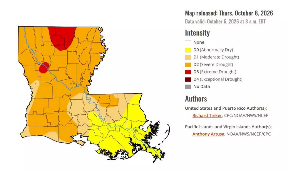
The "danger" from this system won't be in the form of severe storms or flooding rains. The "danger" will actually be more of what we've had for several weeks. Extremely dry conditions. The passage of a cold front will lower humidity, making conditions around Central and Southern Louisiana even more conducive to fire danger. See Louisiana's Fire Danger Map here.
The National Weather Service Forecast Office in Lake Charles has created a nice graphic that sums up the concerns and where the greatest concerns across the state happen to be.

Obviously, anyone who might be considering doing some trash burning or lighting a fire of any magnitude should rethink that or at least make sure they have the situation well under control before lighting that first match. But another concern with conditions like these would be carelessly discarded cigarettes. Not only is that littering, but you could burn down a forest if you don't find an ashtray.
Forecasters expect the dry conditions to not only persist but worsen following the passage of the cold front late on Friday or early Saturday. There is very little moisture associated with the cold front, so we might not see any rain at all. We will have much cooler temperatures.
When Will It Actually Feel Colder in Louisiana
By Saturday morning, temperatures will be in the lower 60s; the afternoon high temperature will be near 80. Sunday morning's low temperature will be in the mid-50s, but the mercury will rise to the mid-80s by Sunday afternoon.

And while cooler temperatures sound nice, they also make people want to start fires in fire pits and do bonfires after ball games. If that's you, we urge you to check with your local officials to see if outdoor burning is allowed or a good idea.
READ MORE: 5 Easy Ways to Keep Bugs Away From Your Patio and Porch
Based on the extended forecast for the next two weeks, it looks as if South Louisiana's next chance of significant rainfall won't come until a week from today, Monday the 12th, so if you have plants that you care about, you're going to want to keep them watered.
But at least conditions will be great for visiting a corn maze or two over the next few weekends. You shouldn't have any problem with mud on your boots, anyway.
Corn Mazes Across Louisiana This Fall 2026
Gallery Credit: Jude Walker